Plate Tectonics
Plate Tectonics vs. Continental Drift
In 1912, a German meteorologist named Alfred Wegener proposed a ridiculous hypothesis that he called "Continental Drift." Ever since the first explorers crossed the Atlantic Ocean and mapped the coast of South America (as well as Africa around the same time), people noticed that the shape of the west coast of Africa looked very similar to the shape of the east coast of South America. Some even put forth the idea that maybe, just maybe, they were once connected. The problem arose with how they got separated if they had been connected. The only explanation considered was Noah's Flood. At this time, that was the only global catastrophe thought to be powerful enough to separate such large land masses. But that's as far as it ever got...until 1912. Wegener made a similar observation about the coasts of Africa and South America. He just went further with it. Being a meteorologist and a geophysicist, Wegener looked at fossil finds, geologic formations, and even climate belts on both sides of the Atlantic Ocean. He noticed that the similarities between Africa and South America did not stop at the coastlines. Everything was too similar to be coincidental so they must have been connected in the past. Still, though, the question remained: how did they separate? Wegener's solution was that not only were Africa and South America connected, but that all the continents were once connected as a supercontinent that he named Pangaea. Then, the continents all moved by "drifting" across the ocean floor to their current positions. The ocean floor was thought to be completely flat and featureless up until the late 1940s. So, the continents plowed over the ocean floor after Pangaea broke up. How? Wegener proposed that the Earth's spin and the Moon's gravity shook and dragged the continents across the ocean floor. He was widely criticized and laughed at by the scientific community.
But Wegener was right...about Pangaea. Nothing else. We know now that Pangaea did exist. It formed around the end of the Permian period about 250 million years ago. But he was wrong on the mechanism of movement for the continents. The Moon only affects the ocean tides. The spin of the Earth, while fast, does not affect the movement of land masses. Without a mechanism to account for the motion, the idea of Continental Drift falls apart: continents don't drift and oceans aren't flat, featureless areas covered with water. But Pangaea lives on...in the Theory of Plate Tectonics.
Plate Tectonics got its first breath of life not long after Wegener's hypothesis got published. It was proposed that new ocean crust was being created at possible spreading zones under the ocean. Unfortunately, nobody could say where this was happening or why the Earth wasn't getting bigger if new crust was constantly being made. Next, it was suggested that the Earth's interior maintained a convection current that brought heat from the core to the surface. Then, in the 1940s, the world went to war. One of the major weapons in WWII was the submarine. Submarines cannot see, visually, underwater. Also, other people need to know where they are. So, SONAR (SOund Navigation And Ranging) was invented. One of the unintended consequences of SONAR was that we were able to finally "see" the bottom of the ocean. After WWII, Harry Hess used this technology to explore the ocean floor. He discovered that there were trenches to correspond with large mountain ranges under the water. The mountain ranges were the spreading centers and the trenches were where the crust was "recycled" by going back into the mantle. "It explains everything," Hess claimed after making this realization.
Add to this the information data from reading the magnetic reversals experienced by Earth over past hundred million years. Right now, magnetic north is near the North Pole and magnetic south is near the South Pole. Every now and then, the poles reverse. We combine this with the age of rocks and we get a great picture of what's happening in the Earth's past.
|
|
|
Plate Boundaries
Convergent
Convergent boundaries occur when two plates are colliding or moving toward each other. There are three types of convergent boundaries: continent-continent; continent-ocean; and ocean-ocean.
Convergent boundaries occur when two plates are colliding or moving toward each other. There are three types of convergent boundaries: continent-continent; continent-ocean; and ocean-ocean.
|
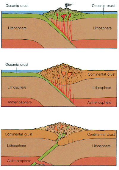
Continent-Continent
When two continental plates collide, the result is a really tall mountain range. Since the continental crust is so thick, there's nowhere for it to go, but up. Imagine a bed sheet on a bed with a person on either side. Each person, at the same time, pushes the sheet toward the other side. What happens? Well, the bed's not going to open up and allow the sheet to fall down, so it crumples up in the center. That's essentially what happens with this type of convergent plate boundary. Examples: the Himalayas, which are the highest mountains in the world, were formed (and are still rising) when India slammed into Asia (India is still plowing into Asia); and the Appalachians were formed about 250-300 million years ago when what is now Africa rammed into what is now North America (it's speculated that the Appalachians used to be as high as, if not higher than, the Himalayas, but 300 million years of erosion has shortened and rounded the peaks). |
Continent-Ocean
When an ocean crustal plate and a continental plate collide, mountains are formed, but in a different way. Since the ocean crust is so much thinner and denser than the continental crust, the ocean crust dives below the continental crust. This is called subduction. As the ocean crust subducts underneath the continental crust, it drags the edge of the continental plate with it a little creating a trench. Also traveling down with the ocean crust is a little ocean water. This water lowers the melting point of the ocean crust rock making it melt easier. After it melts, it rises up as it is less dense than the surrounding rock. As it moves up through the continental crust, it melts some of the surrounding continental rock making it a combination of melted ocean and continent rock. Finally, it reaches the surface as a composite volcano (see the next page for information on volcanoes). Examples: The Andes mountains in South America were formed by the Nazca ocean plate subducting under the South American continental plate; and the Cascades in the Pacific Northwest of America were formed by the Juan de Fuca ocean plate subducting under the North American continental plate (all of these mountains are volcanic). |
Ocean-Ocean
When two ocean plates collide, it's more similar to the continent-ocean convergence than to the continent-continent convergence. Whichever ocean plate is denser is the one that subducts beneath the other. Again, a trench forms. These trenches are the deepest places on Earth. The deepest is at the bottom of the Mariana Trench at a location called Challenger Deep. It is so deep that if you placed Mt. Everest (almost 6 miles in height) at the bottom, it would not break the ocean's surface. Only 3 people have ever been to the bottom of it...ever! As the plate dives underneath, it melts as well. The volcanoes that form from this melt, though, are underwater. When they break the surface of the water, they form what is called an island arc. The best example of this is Japan. All of the islands of Japan were formed by this process. |
Divergent
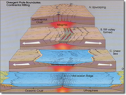
Divergent boundaries occur where one plate is splitting into two plates or two plates are moving away from each other. There are two types of divergent boundaries: continental and oceanic.
Divergent boundaries occur where one plate is splitting into two plates or two plates are moving away from each other. There are two types of divergent boundaries: continental and oceanic.
|
Continental Divergence
In Eastern Africa, the "horn" is breaking off from the continent. For the entirety of human history, this split has been occurring. Eventually, the split will connect to the sea and seawater will rush in, creating a new island off the coast of Africa. When the continent splits like this, it falls in blocks since it is so thick. This creates a rift valley. The land drops as it rifts and the valley slowly widens. When the mantle is reached, the magma pours out as flood basalts or cinder cone volcanoes. Eventually, the split reaches the ocean and a new landmass and body of water are born. Example: the Great Rift Valley in Eastern Africa. |
Oceanic Divergence
Under the Atlantic Ocean, we can find the longest mountain chain on the planet (and possibly the Solar System). The Mid-Atlantic ridge was created when the ocean formed by splitting apart. At the bottom of the ocean, the crust is thin, but it still falls a little and creates a small rift valley. Once the magma/lava reaches the water, it immediately cools and hardens. But the crust is still splitting, so more and more hardened lava forms over the rift, eventually creating a ridge...a mid-ocean ridge. Example: the Mid-Atlantic Ridge. |
Transform
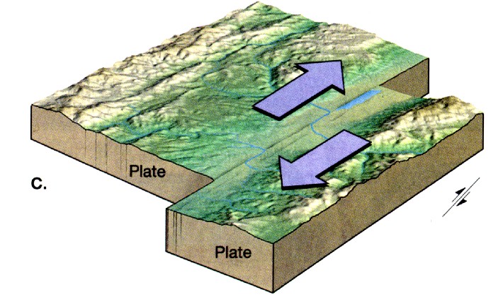
Transform plate boundaries occur where two plates slide past each other in a horizontal fashion. This plate boundary corresponds to the strike-slip variety of faults (faults are discussed on the next page). The best example of a transform plate boundary is the San Andreas Fault in California. The cause of the earthquakes that plague this state, the San Andreas Fault system is one section along a transform plate boundary that's causing this part of California to slide north toward Alaska, while the the rest of the state and the US is rotating slightly counter clockwise. Example: San Andreas Fault.
Transform plate boundaries occur where two plates slide past each other in a horizontal fashion. This plate boundary corresponds to the strike-slip variety of faults (faults are discussed on the next page). The best example of a transform plate boundary is the San Andreas Fault in California. The cause of the earthquakes that plague this state, the San Andreas Fault system is one section along a transform plate boundary that's causing this part of California to slide north toward Alaska, while the the rest of the state and the US is rotating slightly counter clockwise. Example: San Andreas Fault.
